Trajectories of land-use and land cover changes in forest reserves of Ondo State, Nigeria
Abstract
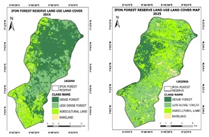
Land-use and land-cover (LULC) change detection has been integrated into sustainable forest management practices to support decision-making. Therefore, we quantified and mapped LULC in Akure-Ofosu, Ala, and Ifon forest reserves between 1995 and 2025. Image classification was performed using supervised maximum-likelihood classification in ArcGIS to identify cover categories. Accuracy and Kappa statistics were higher than 85% and 75%, for all land-use types and years, indicating a reliable classification. In Akure-Ofosu, dense forest declined from 35,750 ha in 1995 to 16,857 ha in 2025, while less dense forest, agricultural land, and bare land increased to 5,457 ha, 10,881 ha, and 479 ha by 2025. In the Ala Forest reserve, dense forest declined from 8,378 ha in 1995 to 6661 ha in 2025. Less dense forest plummeted to 3894 ha, while agricultural areas increased to 7378 ha over the same period. In Ifon forest reserve, dense forest decreased from 15, 799 ha in 1995 to 6296 ha in 2025, less dense forest, agricultural areas increased from 7197 ha to 9709 ha, and 4078 ha to 9968 ha. Our findings showed that the forests have been heavily degraded and provide valuable information that is a useful guide for conservation efforts.
Keywords: Forest retraction, change detection, supervised classification, ArcGIS, forest conservation